


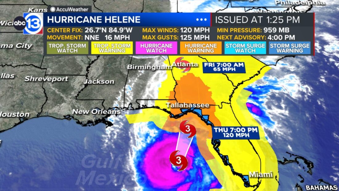
September 26, 2 p.m.
Hurricane Helene is now a major category 3 wind storm with 120 mph winds. It is accelerating toward Florida’s Big Bend and will move quickly through Georgia overnight. Due to this unprecedented combination of strength and forward speed in this part of the country, the storm surge will be catastrophic and possibly record-setting. New hurricane model data also indicates hurricane-force wind gusts of 80-100 mph will be common across much of the eastern half of Georgia. Sustained wind speeds will be significantly lower, but the gusts will do significant damage to trees, buildings, and power infrastructure from Florida to Georgia and possible into the western Carolinas, too.
September 26, 10 a.m.
Helene becomes a Category 2 hurricane is expected to intensify to a Cat 3 Hurricane at landfall near Apalachicola this evening. Helene is a large hurricane with a large portion of the southeast US likely to see impacts such as life-threatening flooding, damaging winds, power outages and isolated tornadoes. There can be up to 15-20 feet of storm surge flooding for much of the Big Bend of Florida.
Tropical Storm Isaac has formed in the North Atlantic and will move east without impacts to land.
September 25, 4 p.m.
Helene is still a Category 1 hurricane as it moves into the southern Gulf of Mexico. It is now expected to become an even stronger hurricane… becoming a Cat 4 with 130 mph winds by Thursday afternoon. Landfall expected in the Big Bend region of Florida Thursday evening. Helene is on track to remain a hurricane as it moves north through Georgia… weakening to a tropical storm in northern Georgia.
https://www.facebook.com/v12.0/plugins/post.php?app_id=&channel=https%3A%2F%2Fstaticxx.facebook.com%2Fx%2Fconnect%2Fxd_arbiter%2F%3Fversion%3D46%23cb%3Df96f3f1e90cb2f940%26domain%3Dabc13.com%26is_canvas%3Dfalse%26origin%3Dhttps%253A%252F%252Fabc13.com%252Ff03852fd83a983442%26relation%3Dparent.parent&container_width=344&href=https%3A%2F%2Fwww.facebook.com%2FTravisABC13%2Fposts%2Fpfbid02z9rBiTqp56Pr5nwu3ayxnojHuhJnj7sVBWtEVZt39qWfHRogXfTT1qGNKGopcvNml&locale=en_US&sdk=joey
September 25, 10 a.m.
Helene becomes a hurricane. Helene has been upgraded to a Category 1 hurricane with 80 mph max sustained winds as it makes its way into the southeastern Gulf. Helene is expected to intensify into a major hurricane before making landfall in the Big Bend region of Florida Thursday evening. Life threatening storm surge, damaging winds, and flooding rains are anticipated across parts of Florida with hurricane force wind gusts possible all the way north into Atlanta, Georgia.
September 25, 7 a.m.
Helene remains a strong Tropical Storm Helene as it brushes the coast of the Yucatan Peninsula. It is expected to move north into the southeastern Gulf Wednesday nearing hurricane strength. It looks to most likely make landfall in the Big Bend or Panhandle area of Florida Thursday as a major category 3 or higher hurricane. No impacts are expected for Texas.