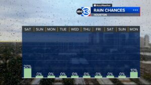


HOUSTON, Texas (KTRK) — The heat ridge is back, which means we’ll have fewer storms and hotter temperatures in the days to come. Our northern counties will have the highest rain chance, but even that chance will be low.
The highest heat index values will be in our western counties. A Heat Advisory from 1 pm to 8 pm Tuesday. Heat index values up to 110 expected for inland Jackson, Austin, Brazos, Burleson, Colorado, Grimes, Waller, Washington, and Wharton counties.
By Wednesday morning, we’ll have to monitor, a complex of storms that will approach our northern counties bringing a few scattered showers and storms to our area. The strength of these storms are still uncertain. We’ll continue to keep an eye on it!
Just how intense is this heat going to get?
As temperatures approach the middle 90s this week, feels-like temps will get close to the danger level of 108.
Hurricane season is right around the corner! Anything I should be aware of now?
There’s nothing threatening in the Gulf of Mexico right now. What you need to know is that NOAA released its Atlantic Hurricane Season Outlook for the 2024 season this week. They are predicting an extremely active season with 17-25 named storms, 8-13 hurricanes, and 4-7 major hurricanes possible.
13 ALERT RADAR MAPS:
Montgomery/Walker/San Jacinto/Polk/Grimes Counties
Fort Bend/Wharton/Colorado Counties
This story comes from our news partner ABC13 Houston.